
AI Maps Earth with 10-Meter Precision Using Satellites
Discover how Google’s AlphaEarth AI maps the globe with 10-meter precision. Explore the future of satellite mapping technology today!
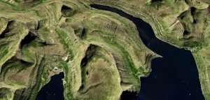
AlphaEarth AI Mapping Technology Overview
Introduction to AlphaEarth AI
Google’s AlphaEarth AI is a groundbreaking technology that leverages advanced artificial intelligence to map any 10-meter area on Earth using satellite data. This innovation marks a significant leap in geospatial analysis, enabling detailed and accurate mapping that was previously unattainable with traditional methods.
Data Acquisition and Processing
The core of AlphaEarth AI’s functionality lies in its ability to process vast amounts of satellite data efficiently.
Utilizing high-resolution imagery, the AI system analyzes and interprets various geographical features, ensuring that even the most remote areas are accurately mapped. This data is processed through sophisticated algorithms that enhance image clarity and detail, providing a comprehensive view of the Earth’s surface.
AI-Driven Insights
AlphaEarth AI harnesses machine learning to extract meaningful insights from the satellite data.
By identifying patterns and anomalies, the technology can predict environmental changes, monitor land use, and assist in urban planning. This capability is crucial for addressing global challenges such as climate change, deforestation, and disaster management.
Applications and Impact
The applications of AlphaEarth AI are vast and varied.
In agriculture, it helps optimize crop management by providing precise data on soil conditions and weather patterns. In urban development, it aids in planning sustainable cities by analyzing infrastructure and population density.
Moreover, conservationists benefit from its ability to track wildlife habitats and monitor ecological changes.
Future Prospects
As AlphaEarth AI continues to evolve, its potential to transform industries and improve our understanding of the planet is immense. Future developments may include real-time mapping capabilities and integration with other technologies, such as augmented reality, to provide even more immersive and interactive experiences.
The ongoing refinement of this technology promises to unlock new possibilities for innovation and exploration.
Benefits of Satellite Data Mapping
Enhanced Environmental Monitoring
Satellite data mapping allows for comprehensive monitoring of environmental changes across the globe. With technologies like Google’s AlphaEarth AI, it is possible to observe and analyze alterations in ecosystems, deforestation, and urban sprawl with precision.
This capability is crucial for understanding the impacts of climate change and for developing strategies to mitigate its effects.
Improved Disaster Response
In the event of natural disasters, timely and accurate information is vital for effective response and recovery efforts. Satellite data mapping provides real-time insights into affected areas, enabling emergency services to allocate resources efficiently and prioritize areas in need.
This technology can significantly reduce response times and improve the coordination of relief efforts.
Precision Agriculture
Farmers and agricultural professionals can benefit greatly from satellite data mapping. By providing detailed information on soil conditions, crop health, and weather patterns, satellite imagery helps optimize farming practices.
This leads to increased crop yields, reduced resource waste, and more sustainable agricultural practices.
Urban Planning and Development
Urban planners and developers can leverage satellite data mapping to better understand land use patterns and infrastructure needs. With detailed maps of any 10-meter area on Earth, planning for transportation networks, housing developments, and public amenities becomes more informed and efficient.
This results in more sustainable and livable urban environments.
Enhanced Security and Surveillance
Satellite data mapping plays a crucial role in national security and surveillance operations. By providing high-resolution images of vast areas, it supports border security, monitors illegal activities, and aids in the detection of potential threats.
This enhances the ability of governments and organizations to maintain safety and security.
Scientific Research and Exploration
For scientists and researchers, satellite data mapping is an invaluable tool for studying the Earth’s surface and atmosphere. It facilitates the exploration of remote and inaccessible areas, contributing to a better understanding of our planet’s geophysical and biological processes.
This knowledge is essential for advancing scientific discoveries and innovations.
Applications in Various Industries
Urban Planning and Development
Google’s AlphaEarth AI offers transformative potential in urban planning and development. By providing precise, up-to-date satellite imagery, urban planners can analyze land use patterns, monitor urban sprawl, and optimize infrastructure development.
This technology enables cities to become more sustainable by identifying areas for green space expansion and improving traffic management systems.
Agriculture
In agriculture, AlphaEarth AI aids farmers in precision farming techniques. By mapping out soil conditions, crop health, and irrigation needs with high accuracy, farmers can enhance yield and reduce resource wastage.
The AI’s ability to monitor large tracts of land in real-time allows for timely interventions, such as pest control and fertilization, ultimately boosting productivity.
Environmental Conservation
Environmentalists benefit from AlphaEarth AI’s capabilities in tracking deforestation, habitat destruction, and climate change impacts. The AI’s detailed mapping assists in preserving biodiversity by identifying critical areas for conservation efforts.
Additionally, it supports the monitoring of natural disasters, aiding in rapid response and recovery efforts.
Disaster Management
AlphaEarth AI plays a crucial role in disaster management by providing real-time data on affected areas. This information is vital for emergency responders to assess damage, allocate resources efficiently, and plan evacuations.
The technology also aids in predicting natural disasters, such as floods and hurricanes, by analyzing weather patterns and geographical vulnerabilities.
Transportation and Logistics
In the transportation and logistics sector, AlphaEarth AI enhances route optimization and fleet management. By analyzing traffic patterns and road conditions, companies can reduce delivery times and fuel consumption.
The AI also supports the development of autonomous vehicles by providing detailed maps that improve navigation and safety.
Real Estate
Real estate professionals utilize AlphaEarth AI to assess property values and identify investment opportunities. The AI’s mapping capabilities allow for a comprehensive analysis of neighborhood trends, infrastructure development, and environmental factors, enabling informed decision-making in property transactions.
Future Developments and Enhancements
Increased Precision and Detail
As technology progresses, one of the primary focuses for Google’s AlphaEarth AI is to enhance the precision and detail of its mapping capabilities.
By leveraging advancements in satellite technology and AI algorithms, future iterations aim to map areas with even finer granularity. This could mean capturing details at a sub-meter level, allowing for more accurate representations of geographical features and urban landscapes.
Such improvements could revolutionize industries reliant on detailed geographical data, such as urban planning, agriculture, and environmental monitoring, providing them with unprecedented insights and tools for decision-making.
Real-Time Updates and Monitoring
Another exciting development on the horizon is the potential for real-time updates and monitoring.
By integrating real-time data feeds from satellites and other sources, AlphaEarth AI could offer dynamic maps that reflect current conditions. This capability would be invaluable for applications such as disaster response, traffic management, and climate change tracking.
Real-time monitoring could also enhance the accuracy of predictive models, enabling proactive measures in various sectors, from emergency services to logistics.
Integration with Augmented Reality (AR)
The integration of AlphaEarth AI with augmented reality (AR) technologies presents a promising avenue for future enhancements.
By overlaying detailed satellite maps onto the physical world through AR devices, users could experience an enriched view of their surroundings. This could be particularly beneficial for navigation, tourism, and educational purposes, offering interactive and immersive experiences.
Such integration could transform how users interact with geographical data, making it more accessible and engaging for a broader audience.
Enhanced Accessibility and User Experience
Improving accessibility and user experience is a key focus area for future developments.
Efforts are underway to make AlphaEarth AI more user-friendly, ensuring that individuals with varying levels of technical expertise can easily navigate and utilize its features. This includes optimizing the platform’s interface, enhancing voice command capabilities, and providing multilingual support.
By prioritizing accessibility, Google aims to democratize access to geographical data, empowering users worldwide to harness the power of AlphaEarth AI for personal and professional applications.
FAQ
Q1: What are the costs associated with using Google’s AlphaEarth AI Maps for satellite data analysis?
A1: The costs associated with using Google’s AlphaEarth AI Maps can vary depending on several factors, such as the scale of usage, the specific features required, and whether you are using the service for commercial or educational purposes. Typically, Google offers a tiered pricing model for its cloud-based services, which may include a free tier with limited access and usage, and paid tiers that provide more comprehensive access and advanced features. It is crucial for potential users to review Google’s pricing documentation or contact their sales team to get a detailed understanding of the costs involved. Additionally, organizations should consider the potential need for additional resources, such as data storage or processing power, which could impact the overall cost of implementing AlphaEarth AI Maps.
Q2: Is Google’s AlphaEarth AI Maps accessible to non-engineers, and how user-friendly is it?
A2: Google’s AlphaEarth AI Maps is designed to be accessible to a broad audience, including non-engineers. The platform offers a user-friendly interface that allows users to interact with satellite data without requiring extensive technical expertise. Google often provides comprehensive documentation, tutorials, and support resources to help users get started and make the most of the platform. However, while the basic functionalities are accessible, more advanced features may still require some technical knowledge or collaboration with technical experts. Organizations may need to invest in training or hire skilled personnel to fully leverage the platform’s capabilities, especially if they aim to integrate it with other systems or customize it for specific applications.
Q3: What are the implementation challenges and compatibility concerns when integrating AlphaEarth AI Maps with existing tools?
A3: Implementing AlphaEarth AI Maps and ensuring compatibility with existing tools can present several challenges. One of the primary concerns is ensuring that the data formats used by AlphaEarth are compatible with the organization’s current systems. This may require data transformation or the use of APIs to facilitate smooth integration. Additionally, organizations might face challenges related to data privacy and security, especially if they are dealing with sensitive information. Ensuring compliance with relevant regulations and implementing robust security measures are crucial steps in the integration process. Furthermore, there could be a learning curve associated with adopting new technology, which might necessitate training for staff or hiring experts to manage the transition. Lastly, organizations should evaluate the scalability of their infrastructure to accommodate the potentially increased data load and processing demands that come with using advanced satellite mapping tools like AlphaEarth.
Takeaway
“Ready to revolutionize your workflow? Try our AI tool today for smarter solutions. Stay ahead of the curve with the latest tech trends – subscribe now. Join our vibrant tech community and be part of the conversation. Let’s innovate together!” Industry analysts believe this signals a shift in market dynamics.


Comments